Rare but deadly natural phenomena: a fascinating look at the extraordinary forces of the Earth


Nature is an accomplished artist, painting our world with stunning landscapes and amazing phenomena. While many natural events are beautiful and benign, some remain shrouded in mystery and danger. In this article, we delve into rare and deadly natural phenomena that challenge our understanding of the world. From firestorms to strange underwater events, these events remind us of the power and unpredictability of our planet.
Show key points
- Anvil-shaped storm clouds, known as cumulus anvil clouds, can unleash powerful lightning strikes and signal severe weather like hurricanes and heavy rain.
- Morning Glory Clouds are rare, fast-moving, tube-shaped clouds found in northern Australia that can unexpectedly disrupt air travel.
- Red rain, occasionally observed in India and Sri Lanka, results from colored particles or algae mixed with rainwater, offering a glimpse into Earth's mysterious processes.
- ADVERTISEMENT
- Foamy tides created by the reaction of seawater with organic compounds can affect marine life and human health due to pollutants they may carry.
- Ghost apples form when frozen apples melt and their soft interiors slip out, leaving behind delicate ice shells that cling to tree branches in cold climates.
- Venezuela's Catatumbo lightning produces persistent, spectacular thunderstorms due to unique geographical and atmospheric conditions.
- Jellyfish lightning, also called red goblins, are upper-atmosphere electrical flashes resembling jellyfish, triggered by strong thunderstorm activity and ionospheric interaction.
1. Anvil of clouds and lightning
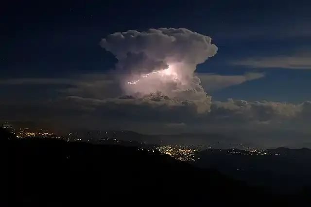
Oak clouds, also known as cumulus anvil clouds, are huge storm clouds with flat anvil-shaped peaks. These towering formations can produce powerful lightning strikes that pose a serious threat to anyone who falls in their path. The electrical discharge caused by these clouds can be fatal, making it a rare but dangerous phenomenon.
Recommend


An anvil cloud is formed when the cumulus cloud reaches the level of stratospheric stability and forms a flat anvil-shaped top. It indicates a thunderstorm in its mature stage, succeeding the cumulus phase. These clouds are usually associated with extreme weather, including heavy rain, downward eruptions, and sometimes hurricanes.
2. Morning Glory Clouds

Imagine waking up to a rolling tube-shaped cloud that runs across the sky. This is the morning glory cloud, a rare weather phenomenon observed in northern Australia. These long clouds move quickly, creating a mesmerizing display. Although they are not directly harmful, their unexpected movements can surprise pilots and disrupt air travel.
Morning glory clouds can stretch up to 1,000 kilometers (621 miles) and move at speeds of up to 60 kilometers per hour (37 miles per hour). They are formed as a result of certain climatic conditions, including low temperature, high pressure, and a strong sea breeze. The exact mechanism behind its formation remains unclear, but it continues to attract the attention of observers.
3. Red rain
In India and Sri Lanka, residents sometimes experience red rain. This unusual precipitation occurs when dust particles or algae stain raindrops, giving them a reddish color. Although Red Rain is not directly deadly, it serves as a reminder of the planet's complex and sometimes bizarre processes.
The phenomenon of red rain occurred in Kerala in the Wayanad district, Malabar, on July 15, 1957, and again from July 25 to September 23, 2001. The heavy red-colored rains puzzled scientists and aroused their curiosity. While the exact cause is still debated, some theories suggest that the aerobic spores of the microalgae Trentepohlia annulata contribute to this phenomenon.
4. Foamy tides

When seawater mixes with organic and inorganic molecules, it can create a foamy tide. These foam waves crash into the beaches, captivating beachgoers. Although not deadly per se, they can carry pollutants and harmful substances, affecting marine ecosystems and human health.
Foamy tide is caused by various factors, including wind patterns, wave movement, and the presence of organic matter. Foam is produced by the reaction of dissolved organic compounds with air and water turbulence. Although their appearance is not rare, they can be eye-catching and interesting.
5. Apple ghost

In colder climates, frozen apples can sometimes thaw and leak, leaving behind thin ice crusts known as ghost apples. These transparent residues stick to tree branches, resembling ethereal fruit. Although not directly harmful, it serves as a testament to the delicate balance between temperature, water and the ingenuity of nature.
The ghost apple phenomenon in Michigan occurred due to the freezing of the rotting apple layer due to rain. When Andrew Setsma pruned the apple trees, the soft interiors slipped, leaving behind the cryosphere. These "Jonaghosts" have captured attention and gone viral on social media.
6. Lightning Catatumbo
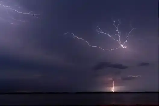
Over Venezuela's Catatumbo River, a constant thunderstorm rages on. This phenomenon, known as catatombo lightning, occurs almost every night and produces a startling display of electrical discharges. Although extreme lightning is not fatal in itself, it can pose risks to people in the vicinity.
Catatumbo lightning results from the confluence of warm, moist air from Lake Maracaibo and cold air from the Andes. Geography and unique weather conditions create a constant lightning show, earning it the nickname "Eternal Storm
7. Jellyfish lightning (red goblins)

Jellyfish lightning, also known as red goblins, is a captivating weather phenomenon that occurs over thunderstorms. These elusive events appear in the form of red or pink flashes and are rarely visible from the ground. Red goblins have a jellyfish-like shape, with tendrils reaching down and a larger halo-like structure at the top. They usually appear directly above large thunderstorm systems or cumulus clouds. The reddish-orange color of the red orcs turns bluish at low altitudes. Red goblins result from the complex interaction between thunderstorm activity and the Earth's upper atmosphere. When a powerful lightning strike occurs, it creates an electrical imbalance between the thunderstorm and the ionosphere (the highest atmospheric layer on Earth). Strong electric fields accelerate electrons to high energies, causing them to collide with nitrogen molecules in the atmosphere. The excited nitrogen molecules emit light, resulting in a charming display of the red object.
8. Snow cakes

Ice cake, also known as snowballs, is a rare atmospheric phenomenon that occurs when cylindrical snowballs form naturally. A relatively thin surface layer of loose wet snow is needed. Beneath this layer, there should be a substrate (such as ice or crushed ice) to which wet ice does not stick. The wind or gravity must be strong enough to move the snowballs without blowing them up. Snowballs are more common in mountainous areas, where steep slopes make them easier to move.
9. Sun dogs

Sun dogs, also called parhelia, are another fascinating weather phenomenon. Sun dogs appear as bright spots of light on both sides of the sun. They often surround the sun within a halo of 22 degrees. Sun dogs create a dazzling sight when the sun is low on the horizon. They are caused by the refraction of sunlight by ice crystals in the atmosphere. They are part of the family of halos resulting from this refraction. Look for them in the Northern Hemisphere as the sun drops in the sky.
10. Lenticular clouds

Lenticular clouds are fixed lens-shaped or almond-shaped clouds that form around mountains, hills, and buildings. When moist air is pushed upward above a high geographic feature (such as a mountain or volcano), lenticular clouds can form. As the air cools and the water moisture condenses, these clouds take on their distinctive curved and stratified shapes. Lenticular clouds often appear to be above or hanging from mountain peaks, earning them nicknames such as "cover clouds" or "UFO clouds." Lenticular clouds remain relatively immobile despite strong horizontal winds. They form around the peak of an air wave and disintegrate shortly after that point. Researchers use lenticular clouds to study gravitational waves, which are often invisible to the naked eye.
![]()
Belgrade, Serbia: Europe's new food capital?
Belgrade is now a buzzing foodie hotspot where creative chefs like Vanya Pushkar and Filip Seric reinvent traditional Serbian dishes with fresh flair. From smoked duck with herbs to grilled belly with currant sauce, the city's modern cuisine celebrates rich local flavors in vibrant, stylish settings. more- ADVERTISEMENT
![]()
Blood test uses 'protein clock' to predict risk of Alzheimer's disease and other diseases
Blood test uses 'protein clock' to predict risk of Alzheimer's disease in others more- ADVERTISEMENT
![]()
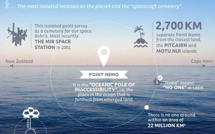
Nemo Point: the most isolated location on the planet
Point Nemo, the ocean’s most remote spot, lies in the South Pacific, 2,700 km from any land. It’s so isolated that astronauts are often the closest humans. Known as a spacecraft graveyard, it’s also inspired fiction from Jules Verne to Gorillaz’s Plastic Beach album. more- ADVERTISEMENT
![]()
Surprising fact: The environmental impact of beef outweighs cars
Surprisingly, beef production harms the environment more than cars, mainly due to cows’ methane emissions and the massive resources needed to raise them. From deforestation to acid rain, the impact is huge. Cutting down beef consumption, even slightly, makes a big difference for the planet. more- ADVERTISEMENT
![]()
Embracing stupidity: the hidden value of our mistakes
Embracing stupidity: the hidden value of our mistakes more- ADVERTISEMENT
![]()
The five scientists who have won two Nobel Prizes – and what sets them apart?
The five scientists who have won two Nobel Prizes – and what sets them apart? more- ADVERTISEMENT
![]()
Princess Tower... The second tallest skyscraper in Dubai
Princess Tower in Dubai Marina stands out with its luxurious design, 101 floors, and stunning views. Once the tallest residential building in the world, it offers elegant apartments, top-notch amenities, and a prime location near shops and transport, making it a dream home and a solid investment. more- ADVERTISEMENT
![]()
Success Guide - How to discover your passion?
Discovering your passion is a personal journey that brings meaning and joy to life. It’s about finding what excites you, motivates you, and makes you feel alive. With patience, reflection, and trying new experiences, you can uncover what truly inspires you without needing to spend a fortune. more- ADVERTISEMENT
![]()
Things people with emotional intelligence never do
Emotional intelligence helps people understand and manage emotions, leading to better relationships, improved teamwork, and stronger mental health. It can be developed through self-reflection, mindfulness, and active listening. Emotionally intelligent people avoid impulsive actions and build balanced lives with better decision-making and communication. more- ADVERTISEMENT
![]()
Discover the Impossible: Turning Deserts into Dense Forests – Dream or Reality?
Desert greening turns dry, barren land into fertile areas using water-saving tech, solar and wind energy, and special soil treatments. One major project, the Sahara Forest Project, aims to fight drought and climate change while boosting local economies by transforming parts of the Sahara and Sahel into green spaces. more- ADVERTISEMENT